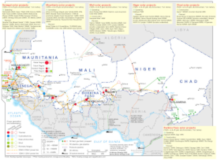
This map provides a detailed overview of solar power sector in the Sahel region, covering Senegal and the G5 Sahel countries (Burkina Faso, Chad, Mali, Mauritania and Niger). The locations of key power generation facilities that are operating, under construction or planned are shown by type – including solar PV, hydroelectricity, wind, biomass/biogas and thermal.
Generation sites are marked with different sized circles to show sites of 10-49MW, 50-199MW, 200-499MW and 500MW and above.
Existing and future transmission and distribution lines are shown ranging 132kV to 330kV. Actual and planned cross-border interconnectors are also shown including lines to Côte d'Ivoire, Ghana, Guinea, Guinea-Bissau and Nigeria.
The map include text panels showing the names, capacities and status of solar projects in each of the Sahel countries. Power generation data is drawn from our African Energy Live Data platform, which contains project level detail on power plants and projects across Africa.
The map also provides an overview of other energy infrastructure across the region, including oil and gas producing areas and associated infrastructure (acutual and proposed) including pipelines and LNG facilities.
The map is presented as a PDF file using eps graphics, meaning that there is no loss of resolution as the file is enlarged.
Single African Energy map
£895
(1 standard map)
Subscribe to African Energy
African Energy is a brand of


