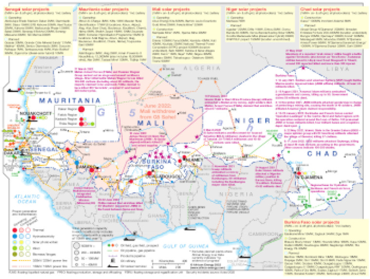
Updated July 2022, the map illustrates key energy infrastructure and recent security incidents across the Sahel, encompassing- Burkina Faso, Chad, Mali, Mauritania, Niger and Senegal.
The locations of security incidents are marked with dates and brief notes explaining the nature of the incidents.
Text panels for each of the countries list operating and planned on-grid and off-grid solar PV projects of 1MW and higrer (noting those that include battery storage)
The locations of power generation facilities that are operating, under construction or planned are shown by type – including thermal, hydroelectricity, solar (PV), wind and biomass/biogas.
Generation sites are marked with different sized circles to show sites of 10-94MW, 50-199MW, 200-499MW and 500MW and above.
Existing and future transmission and distribution lines are shown ranging from 132kV to 330kV. Actual and planned cross-border interconnectors are also shown.
Power generation data was drawn from our African Energy Live Data platform, which contains project level detail on power plants and projects across Africa.
The map also shows areas of oil and gas exploration and production, pipelines, oil refineries and oil tanker terminals.
Single African Energy map
£895
(1 standard map)
Subscribe to African Energy
African Energy is a brand of


